Geography & the American Landscape
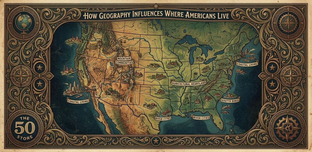
How Geography Influences Where Americans Live
I sit by the window these days, watching the neighborhood kids ride bicycles down the slope of our street. They do not know why the road dips past the oak tree, or why it curves around the creek bed at the bottom. They only know it makes for a fast ride. I smile as they zoom past. I have lived on this street for many decades, watching this vast country grow. We build grand homes, pave highways, and proudly think we are the ultimate masters of the landscape. We plant flags in the soil and draw neat borders on maps. We confidently assume we can live absolutely anywhere we choose. This is the simple situation we accept. We look out at our beautiful country and see endless possibility.
But there is a profound complication hiding just beneath the pavement. The land is never a blank canvas. Long before the first surveyor arrived, the earth had already drafted a permanent master plan. The imposing shape of the hills, the winding flow of deep rivers, and the depth of topsoil laid down strict rules. Our brave ancestors had to listen carefully to those natural rules to survive the winters. If a rushing river turned sharply, the town followed the muddy bank. If a mountain was too steep, the rocky wagon trail snaked quietly around the base. These old, practical choices locked into place over generations. They created invisible boundaries that still dictate our modern lives. We buy suburban homes, raise families, and build communities based entirely on decisions made by pioneers looking for fresh water and flat ground.
This fascinating reality brings us to an important question. How exactly did the ancient, silent terrain beneath our feet decide where our bustling towns and modern neighborhoods would finally take root?
The answer is written deeply in the dark soil, the flowing water, and the open sky above us. Through the invisible, guiding hands of geography, the physical world has always directed our steps, from the early river settlements of our distant past to the massive modern migrations of our present day.
The Hidden Step in the Rivers
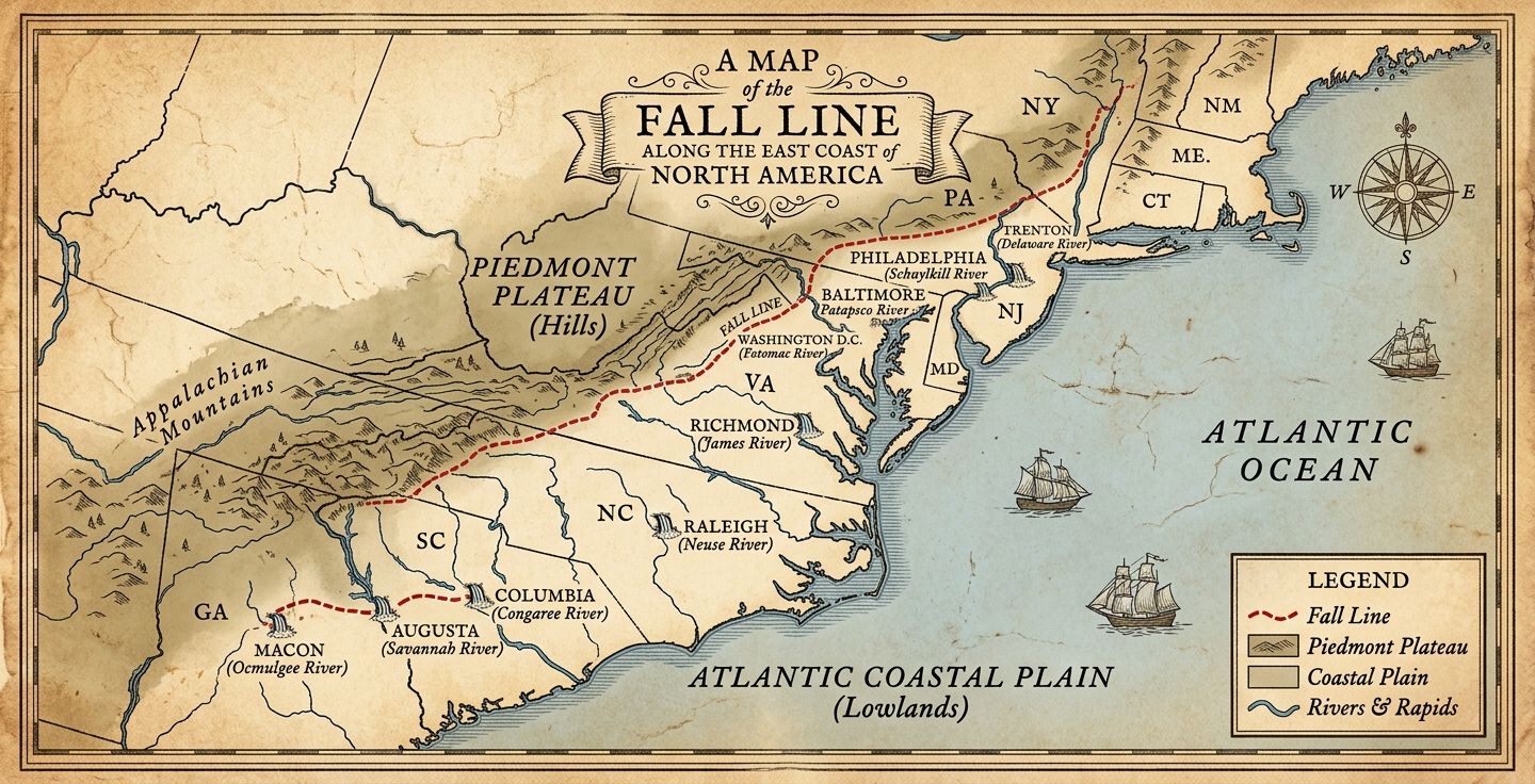
When I was a young boy, my father took me on a train ride down the East Coast. I watched the cities roll by like beads on a string. Years later, I learned about the hidden step in the earth called the Fall Line. This is where hard, ancient rock meets soft coastal soil. When rivers flow over this edge, they drop, creating waterfalls.
Imagine a sailor long ago, navigating a ship up a calm river. Suddenly, he hits roaring white water and can go no further. Crews had to stop, unload cargo, and build warehouses. Soon, a bustling town appeared exactly where the river tumbled over the rocks. This is why cities like Richmond, Washington, Baltimore, and Philadelphia sit in a neat row. A geological hiccup decided the fate of millions.
Let me share a truly surprising fact that always makes me pause in wonder. The National Oceanic and Atmospheric Administration reports that over 39 percent of the United States population lives in counties directly on the shoreline. Think about the magnitude of that for a moment. These coastal areas make up less than ten percent of our land area. Yet, nearly four out of ten Americans are crowded tightly near the edge of the water. Furthermore, the Census Bureau notes that about 80 percent of us live in urban areas covering a mere three percent of the American landmass. We proudly profess our love for wide open spaces, but we naturally huddle together. We instinctively cluster around the waterways and deep harbors our adventurous ancestors first discovered.
Carving a Path Through the Green Wall
Our ancestors were incredibly determined people. The Appalachian Mountains stood like a massive green wall, keeping early settlers trapped close to the Atlantic Ocean. But a brilliant man named DeWitt Clinton (1769-1828) possessed a grand vision. As governor of New York, he pushed tirelessly to dig a massive ditch connecting the Hudson River to the Great Lakes.
People mocked his ambition, calling it an impossible folly, but he persisted. The miraculous result was the Erie Canal.
Consider a hardworking lock-keeper on that brand new canal. Before the water flowed, his town was nothing but a silent clearing in the dense woods. Once the gates opened, he watched thousands of flatboats float gently past, carrying hopeful families toward the fertile Midwest. His quiet street became a vital gateway to a new world. The canal transformed New York into a great global port, all because ordinary people altered the landscape just enough to let water carry their grandest dreams westward.
The Pull of the Western Soil
As brave families moved west, they found land stretching out endlessly like a vast green ocean. Here, the dark soil was the absolute greatest treasure. The abundant natural resources of the American heartland pulled farmers away from the stubborn, rocky fields of the eastern seaboard.
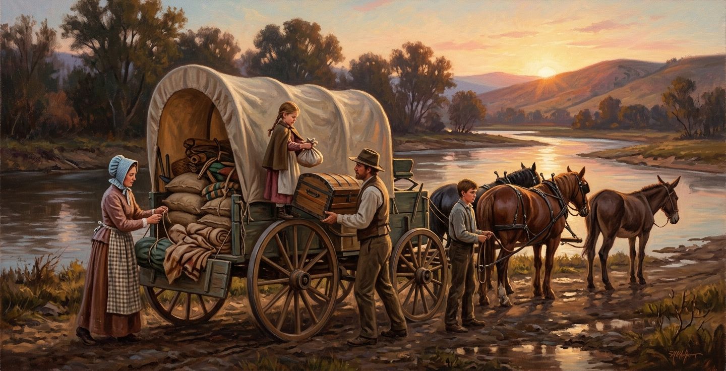
I often picture a young family packing their sturdy wooden wagon, nervously squeezing through the dangerous Cumberland Gap. The journey was bitterly hard. But they ultimately settled where the topsoil was unimaginably rich. They planted fragile seeds, and vibrant farming towns sprouted up. The physical spacing of these midwestern towns was often exactly the distance a tired farmer could travel in one single day by horse. Our maps were meticulously measured by human stamina and the daily setting of the sun.
Learning to Respect the Dry Earth
But the forgiving land changes dramatically once again as you travel further toward the setting sun. The lush green gently fades into shades of brown and red. The western half of our magnificent country is breathtaking, but unforgiving. Water suddenly becomes a rare, precious resource.
A fearless explorer named John Wesley Powell (1834-1902) understood this difficult truth perfectly. Despite losing his right arm in the Civil War, he boldly led a daring expedition down the roaring Colorado River. He brought back a stern warning, telling leaders in Washington that the harsh western climate was entirely too dry for traditional farming.
People desperately wanted to believe the soothing rain would magically follow the plow, but Powell was painfully right. Today, looking down from an airplane over western states reveals bright, isolated clusters of city lights surrounded by vast, empty oceans of darkness. People are forced to gather closely around the few dependable rivers and modern reservoirs. The dry earth still firmly commands exactly where we safely build.
How Sunshine Redrew the Map
In my own lifetime, I have watched a new movement sweep across the map. We now call it the great migration to the Sunbelt. When I was a young worker, household air conditioning was a rare luxury. As it became common in everyday homes, the intense heat of the deep south was no longer a punishing barrier.
Millions of Americans happily traded heavy snow shovels for year-round sunshine, heading to places like Florida, Texas, and Arizona. This demographic shift was massive, yet remained entirely dictated by the natural environment. The human desire for a gentle winter pulled us south. We found delightful new places to thrive, proving that while clever technology helps us adapt, nature ultimately guides our comforts.
I see our grandchildren continuing this eternal journey. They look for peaceful communities situated closely to wild nature. I hold so much bright hope for these younger generations. They are finding beautiful, sustainable ways to respect the earth while building their vibrant lives. They clearly understand the soft ground we stand on is a gift to fiercely protect.
Walking Your Own Streets
The remarkable story of our great nation is a beautiful, intricate dance with the physical landscape. The dirt and rock of our beloved hometown is not just empty ground; it is the living foundation of our entire community, gently shaping exactly how we live, work, and love each other.
I warmly encourage you to take a slow, mindful walk through your own town tomorrow morning. Ask yourself quietly why the busy main street curves the way it does. Look for the nearest trickling creek and wonder how it provided sweet water for the hardworking people a century ago. It is a beautiful, historical puzzle, and you are a lucky, living piece of it. Cherish your unique local landscape, and please do your small part to leave it incredibly healthy for the next wonderful generation.
Questions I Often Hear About Our Land
What is the Fall Line and why is it important?
The Fall Line is a geological boundary where hard, rocky terrain meets softer coastal soils. It is important because rivers flowing over this line create waterfalls and rapids. Early ships could not sail past these points, so people unloaded their cargo and built major cities right there, like Richmond and Philadelphia.
How did rivers shape early American settlements?
Rivers were the first highways. Before we had paved roads or trains, moving heavy goods over land was terribly difficult. Towns grew naturally along riverbanks because water provided drinking resources, powered early mills, and allowed farmers to float their crops to larger markets.
Did the Appalachian Mountains slow down westward expansion?
Yes, they served as a massive physical barrier for many decades. The steep ridges and thick forests kept most early settlers confined to the East Coast. It was not until pathways like the Cumberland Gap were cleared, and the Erie Canal was built, that large numbers of families could finally move westward.
Why did so many people move to the Sunbelt in recent decades?
People moved to the Sunbelt to find warmer weather and new opportunities. This massive shift was made possible by the invention of widespread air conditioning, which finally made the intense summer heat of the South and West comfortable for everyday living.
How do natural resources affect where cities grow today?
While we do not rely on local timber or river currents as heavily as our ancestors did, natural resources still matter. Access to vast amounts of fresh water, flat land for building airports and highways, and pleasant climates all play major roles in deciding which cities continue to grow and thrive.